British seaside resorts came into being as a result of two
historical forces. First the railway which created cheap and speedy travel for
the masses. Second the growth of leisure time for the working classes. From the
mid-19th century onwards a series of Factory Acts imposed limits on
the working week improving conditions for workers which gave them free time at
weekends and holidays. In the North especially in the textile towns of
Lancashire and West Yorkshire there were “wakes weeks” when factories closed
down for essential maintenance freeing mill workers to get away from their smog
polluted streets. The seaside beckoned. Having got the holiday makers there
resorts had to find ways of entertaining them thus piers, fun fairs, amusement
arcades and promenades feature in nearly all seaside towns. Promenades – long
level walkways unaffected by the tide – offered visitors a cost free diversion
appealing to those on tight budgets. Most days of the holiday would start with
a morning stroll.
With the rise of cheap air travel in the 1960s and 70s British coastal towns took a big hit – unemployment became widespread accompanied with the social problems that are associated with economic depression. It was difficult for “Bracing Skegness” and other resorts to compete with the guaranteed sunshine of the Mediterrarean. In recent years however there are signs that some towns are attracting a new generation of visitors. Morecambe is a case in point.
Morecambe’s rail links in the past meant that it was easily accessible to holiday makers from West Yorkshire so much so that in its heyday it became known as Bradford-by-the-sea. Just recently it featured in the police crime drama “The Bay” described by TV critics as a Northern “Broadchurch”. As with many such series the distinctive location becomes as important as the plot and characters. Morecambe certainly has a distinctive location on the edge of the vast bay that takes its name with a superlative view of the mountains of the Lake District across the water. Although this walk is simple to follow and easy to do the reader will find it just as enjoyable as any described on this page.

Fact File:
Time: 3 - 4 hours
Map: OS Explorer 296 Lancaster, Morecambe & Fleetwood

Directions:
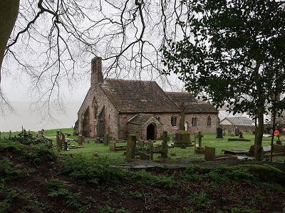
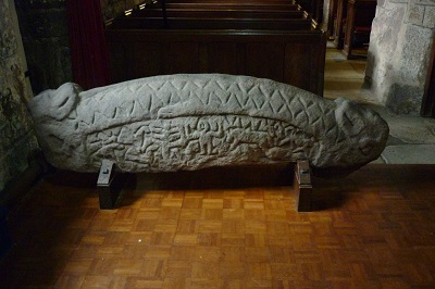
The church dates back to AD967 making it one of the oldest in continuous use in Western Europe. It has many points of interest most notably a Viking hogback stone
dating from the 10th century its carvings intermingling Norse and Christian mythology. Returning to the entrance of the churchyard follow a track leading up to a morsel of National Trust land which is the site of St Patrick's Chapel so called because the patron saint of Ireland was believed meant to have visited it. Now a ruin it has been dated back to the late 5th century. Near it are a set of six graves carved into the stone.

These would have been used for priests or persons of high rank in pre-Norman times. From the chapel follow the path across the Barrows southwards. Soon Heysham Power Station looms into sight.
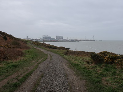
A more striking contrast between ancient and modern would be hard to find. As you near a road end turn left and left again on a footpath taking you Barrows Lane.

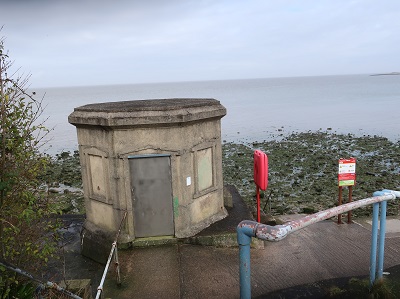
This returns you to the car park. At this point you can decide if the 1 ¼ miles you have walked thus far is enough. For those of you up for something longer head for the promenade. Follow Barrows Lane past St Peter's and after it bends to the right take a footpath on the left that places you on a walkway above the shore close to a concrete utility structure.
In terms of direction there is not a great deal to add except follow the promenade to Morecambe. How far you walk is entirely within your control but it would be amiss not to pay tribute to the statue of Morecambe's most famous son Eric Bartholomew who took the resort's name as his stage name.

Once you have decided you have gone far enough turn around and walk back to Heysham.
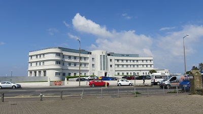
Built in the 1930s this is one of the most important Art Deco buildings in the country. After a period of almost dereliction the building was saved thanks to the efforts of local preservationists and the investment by Urban Splash. In 2008 it was reopened after a lengthy refurbishment and is a popular destination. It features frequently in period dramas especially those inspired by Agatha Christie.