As soon as the potential scale of the epidemic was realised the government imposed what seemed to be draconian measures in an effort to bring it under control. Once a case was identified not only was the infected animal slaughtered but the whole herd/flock was killed with it. In addition in a controversial policy known as “contiguous culling” all livestock within a 3 kilometre radius of the infected farm was to be slaughtered too. The official view was that the risk of spreading the disease was not worth taking. (Imagine a policy of contiguous culling applied to the coronavirus outbreak!) The animals were killed on the site and then disposed of either by cremation or buried in quicklime. One of the worst affected areas was the north west of England and I well remember seeing distance columns of smoke rising from the funeral pyres of sheep and cattle. By the end of the outbreak it is estimated that 6 million animals were killed in a epizootic of over 2,000 cases.
Now we’re in a situation where everyone apart from NHS personnel and key workers is in an open prison – or perhaps more accurately “under house arrest”. What we have been asked to do to prevent the spread of coronavirus is against our nature – to maintain our social distance even from our families, not to gather in groups, not to socialise. Yet nearly everyone understands the reasons for these unprecedented measures – to save lives. If there are too many cases our hospitals will not be able to cope and many people will die as a consequence. Not being able to take exercise far from home is small beer against a person’s life. The main thing to remember is that the countryside will still be there when the coronavirus restrictions are lifted.
One place I am resolved to re-visit when I can will be Hadrian’s Wall. In 2004 not long after the Hadrian’s Wall Long Distance Path was opened I walked the length of the wall from Wallsend near Newcastle to Bowness on Solway to the west of Carlisle. One of my overnights was in a farmhouse B&B at Walton in East Cumbria. At breakfast I commented on how clean the farmyard was and how quiet and then the penny dropped…my hosts had lost their herd three years previously during the foot and mouth crisis.
Start: Steel Rigg National Park Car Park NE47 7AN
Time: 2 hours
Map: OS OL43 Hadrian's Wall

Map by kind permission Johnston Press
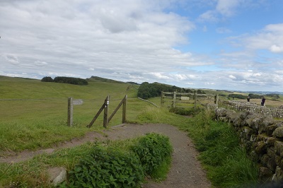
At the rear of the car park go through a gate and following a sign for Hadrian's Wall join the footpath that takes you alongside it.

Basically that's all there is to it! From this point keep on the path as takes you on a roller coaster with fabulous views of a big country.

A mile into the walk you arrive at Sycamore Gap

with its much photographed tree which featured in the 1991 Hollywood film "Robin Hood: Prince of Thieves". Beyond it the path scales Highshield Crags to reward you a bird's eye view of Crag Lough
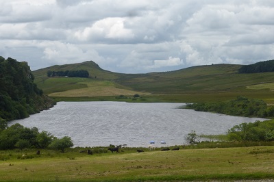
an attractive lake. In another 1 ½ miles

you reach Housesteads site of a large Roman fort.
Follow the signs for the information centre. From here you can catch the 122 bus back to Twice Brewed close to your starting point.