Glenridding
A few days after watching the sunrise over Kirkstone Pass (described on this page last week) I found myself there again when the Norwest Fellwalking Club’s coach suffered a temporary breakdown. Climbing the pass from the A591 a warning signal began to make alarming noises. The driver Tony managed to reach the lay by just beyond the inn and then checking out the side of the bus which was issuing prodigious amounts of water announced he wasn’t going to take the vehicle any further until he had it checked out by the company’s mechanic. This might take a few hours. I was due to help Andy lead a walk from Kirkstone over High Street down to Patterdale and then Glenridding but as I was deputising for the secretary David Johnstone I felt obliged to wait with the driver. Most other members quickly adapted their intended routes and alighted the bus. That left a dozen or so intending to walk from Glenridding our venue for that day. Unfortunately the inn was not open until midday which was exactly the time the next service bus was scheduled to arrive. To pass the time grown men and women were reduced to playing I spy. At noon armed with their bus passes the remaining members bar Norman headed down to Glenridding on the Penrith bus. Norman stayed out of a sense of loyalty which as welcome as it was nonetheless surprised me. Andy and I regard Norman as the hard man of the club going solo over large chunks of trackless wilderness. Perhaps he just wanted an easier day. About 15 minutes later the mechanic turned up, checked out the hoses, put water in something and declared the coach fit to continue. We reached Glenridding at 1.15.Norman went off to his own devices – with my time limited I decided to walk the route David had planned for what is designated as the easiest of our guided walks. It helped rescue the day.
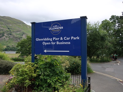
Start/Finish: Glenridding Information Centre and car park CA11 0PA

Fact file:
Distance 7 miles
Time: 2 ½ - 3 ½ hours
Grade: Mainly easy but the terrain becomes progressively rougher the further up Grisedale you venture.
Map OS OL The English Lakes North eastern area
Map by kind permission of Johnston Press
Directions.
From the information centre return to the main road and turn right. Passing between shops and the Glenridding Hotel would be wise to it cross to the pavement opposite. As you reach the entrance of the Ullswater Steamer Company
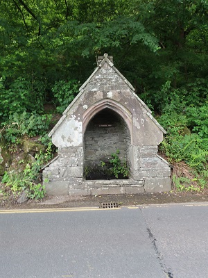
switch back to a pedestrian path that keeps you off the road altogether but first go along the road for about 50yds to view St Patrick's Well.
Returning to the pedestrian path keep on it until it brings you to the edge of Patterdale.
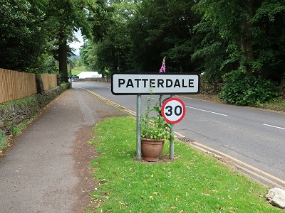
After passing the village sign turn right onto a lane leading you into Grisedale.

Now on an ancient route connecting the settlements at the head of Ullswater to Grasmere. In 200yds the lane divides. Keep right as the lane climbs alongside woodland.

Depending on the season you may have a view of waterfalls to the right as Grisedale Beck cascades down towards Ullswater. In terms of direction there is not much more to add between here and Ruthwaite Lodge 2 ½ miles up the valley aside from noting that on the approach to Elmhow Farm the lane downgrades to a broad track

and then further up becomes a rough track

with the towering presence of Dollywagon Pike ahead and the steep sided slopes of St Sunday Crag to the left. After the farm the climbing hut comes into sight and makes for a helpful reference point. Cross two wooden footbridges. The second
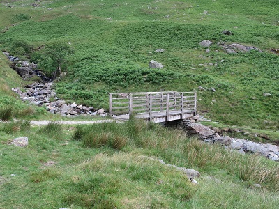
is significant as it is the place you need to return to after visiting the hut. From the bridge climb up steeply until you arrive at the broad platform on which the hut is located.

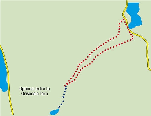
The lodge is a fine place to appraise your progress so far and to appreciate the rugged grandeur of England's proper mountains. You may decide if you have time to visit Grisedale Tarn reached by continuing along the path that brought you up to the hut. Do not let me hold you back. You'll climb another 600feet covering almost a mile to do so and add about an hour to the time indicated above. Back to this route return to the wooden footbridge

but do not cross instead take the rocky narrower path to its left. This leads back down Grisedale

taking you below the Striding Edge the ridge leading up to Helvellyn. After passing Braesteads a large farm to the right

you reach the path leading up to Striding Edge. As indicated by the signpost at this junction
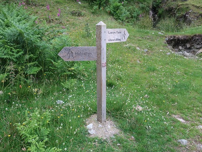
your way is to Lanty's Tarn. A broad track climbs up through bracken towards Keldas the wooded height separating Glenridding and Patterdale. The tarn is charming

and worthy of a visit in its own right but defer any decision to do so until you walk down to Glenridding which is very steep. Past the tarn go through a gate and bear right at a bench taking the path

down to the village. As you reach the edge of the settlement keep right

for the centre.