Start/finish: Grasmere village centre close to St Oswald's church LA22 9SW
Distance: 7 miles including a visit to Loughrigg Fell summit (recommended but avoidable if time and energy levels allow- see below)
Grade: Mainly easy with slopes but the ascent to the top of Loughrigg Fell is strenuous.

Directions: The section of the walk from Grasmere Village to Rydal follows in the footsteps of England's most famous poet - William Wordsworth (1770 - 1850). Given that, it would be almost rude not to pay one's respect to him in person so to speak - his grave, along with those of other members of his family,
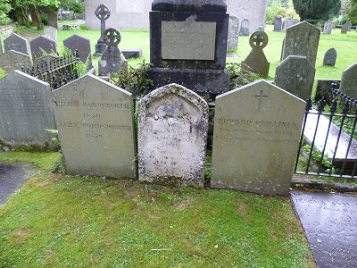
can be viewed to the rear of the churchyard. Duty done back on Stock Lane cross the River Rothay and follow the road up to the intersection with the A591. Cross the roundabout onto the lane taking you past The Wordsworth Museum and Dove Cottage.

Dove Cottage was Wordsworth's home from December 1799 until May 1808 and some of his best poetry was inspired by what he observed on his daily walks.

For the next mile as the track undulates along the slopes of the high fells to the left you are treated with sublime views of Rydal Water down to your right. As you near Rydal a high wall on the right signals the edge of settlement. At the end of the track turn right passing in front of Rydal Mount
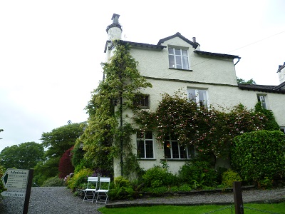
where Wordsworth lived from 1813 until his death in April 1850. As with Dove Cottage it is open to the public. Walk down the lane passing the entrance to Rydal Hall on the left and further along St Mary's church on the right close to Dora's Field a National Trust property.

Dora was Wordsworth's daughter and after she died he and his wife dedicated the field to her memory planting it with hundreds of daffodil bulbs. At the A591 turn left.

left rather than descend to the water's edge. The track leads to old quarry workings that have created a large cave - Rydal Cave in fact.
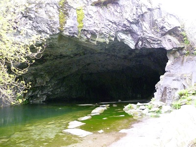
In all likelihood your kids (grandkids) may have not been over impressed with Wordsworth's grave but any loss of cred will be more than made up by checking out this feature. From the cave keep on the terrace path

that contours above Rydal Water for another ½ mile until you are overlooking woodland and the spit of land between Grasmere and Rydal Water. Keeping to the upper path soon you are enjoying more sublime views - this time of Grasmere and the wide sweep of fells that form its backdrop.
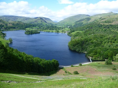
When you arrive on the edge of woodland you have a decision to make - whether or not to climb to the top of Loughrigg Fell the slopes of which you have been hugging since crossing the Rothay. On the downside it is a steep ascent. On the upside it is not a high fell being a little under 1100ft. And on the up upside the views are…well exceptional.

After bagging the summit return to the point you left the path and then continue into woods until you meet the lane leading down from High Close. Turn right. From here you have a little over a mile of (quiet) road walking back to the village.