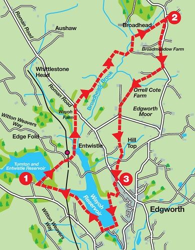
Cross the dam and continue on a track
leading to the side of the Strawbury Duck pub. Turn right on a lane, cross the railway bridge (alternative start if you are arriving by train) and then after 100yds turn left on a footpath
leading downhill to reach a wooden footbridge. Do not cross instead turn left and follow the brook up stream to a small bridge. Turn right across this and climb through a wooded valley. After a stile
follow the path as it enters pasture and climbs to Wayoh Farm. After a stile enter its yard
and then bear right on a drive leading to Blackburn Road. Turn left. After 100yds
turn right on a tarmac farm track. After a metal gate the track divides.
Take the right fork. Keep on the track for a little under ¾ mile as it passes farm buildings at different stages of construction.
When you reach a large barn marked Lower House on the OS map turn right over a stile, descend a marshy field to another and then cross Broadhead Brook by a footbridge.
The path climbs up and bears left across a meadow and after crossing a short wooden walkway across a boggy area, enters a dense hedgerow to emerge in a farmyard. Hard to believe the right of way continues through an arched passageway.
Crossing a lawn
keep ahead to be reunited with Broadhead Brook. The aim now is to follow the stream until it is crossed by Broadhead Road. On reaching a shell of a farm building
bear left just beyond it and then follow the fence line above the infant brook.
As you near the road the path is crossed by another dense hedge.
Cross the awkward stile into a boggy pasture and turn right up to Broadhead Road.
2. Turn right. Stay on Broadhead Road for well over ½ mile. After Passing the Toby Inn turn right at a private road for Higher Barn Farm.
Just after the farm turn left off the main track over a stile
to diagonally cross a large pasture to a stile on its far side. From here descend left to a footbridge
and then climb the opposite bank to reach farmland above the valley.
Here the right of way continues outside the fence (though unofficially it may be easier to step into the field) and brings you to the edge of Orrell Cote Farm. Turn left at the first corner and then right at the second corner
passing through trees to cross the farm yard to a lane. Keep ahead on the tarmac drive for 600yds
until it intercepts Moorside Road. Turn right and after 50 yards turn left
onto a fenced path to enter the complex of Moor Side Farm. Keep ahead between buildings
to a stile leading into pastureland.
Keep ahead to pass through a graveyard of farm machinery to Hill Top Farm. Pass the back of the old farmhouse
and pass the imposing front of a newer one to reach the drive. Turn right and follow the tarmac lane to a squeeze style on the left. Cross the meadow to a gate and turn right. Follow this lane to an intersection and take a footpath to the left of the shed before you.
Follow a wall on the left across a field, cross another to a stile and turn right along a fenced path
to pass between houses and arrive on Blackburn Road.
This traverses open space to Sherwood Fold. Turn left on Horrocks Road.
Follow this until it reaches fields close to a signboard for Edgeworth Quarries.
Turn right on a path leading down to another above Wayoh Reservoir. Turn left on this and follow it to the dam end of the reservoir. Cross to the far side and then turn right along the shore.
Keep on the path until you reach the causeway
where you turn left on a path leading under the railway viaduct
and then reaching the lane leading to the car park.